The Ultimate Guide to Real Estate Drone Photography in 2026
Drone photography for real estate is revolutionizing property marketing in 2026. Aerial images and videos allow potential buyers to see the full property and its surroundings. Studies show homes with drone shots can sell up to 68% faster than those without. With drone technology becoming more affordable and advanced (high-end cameras at mid-tier prices), having eye-catching aerial photos and videos is now essential for competitive property listings.
Why Drone Photography Matters
Aerial imagery provides a unique perspective that ground-based cameras cannot capture. By showcasing a property’s exterior, lot size, and neighborhood from above, drone shots give buyers a comprehensive view. Homes listed with drone photos can sell significantly faster — one study found aerial images helped sell properties up to 68% faster. Drone videos and 3D tours boost buyer engagement significantly (often by 80% or more). These marketing advantages mean a small investment in professional drone imagery can yield big returns in listing exposure.
Key benefits include:
- Faster Sales: Properties with high-quality aerial imagery often spend fewer days on market and can command higher offers.
- Higher Engagement: Aerial visuals increase listing clicks and shares by up to 83%, drawing more buyer interest on social media and websites.
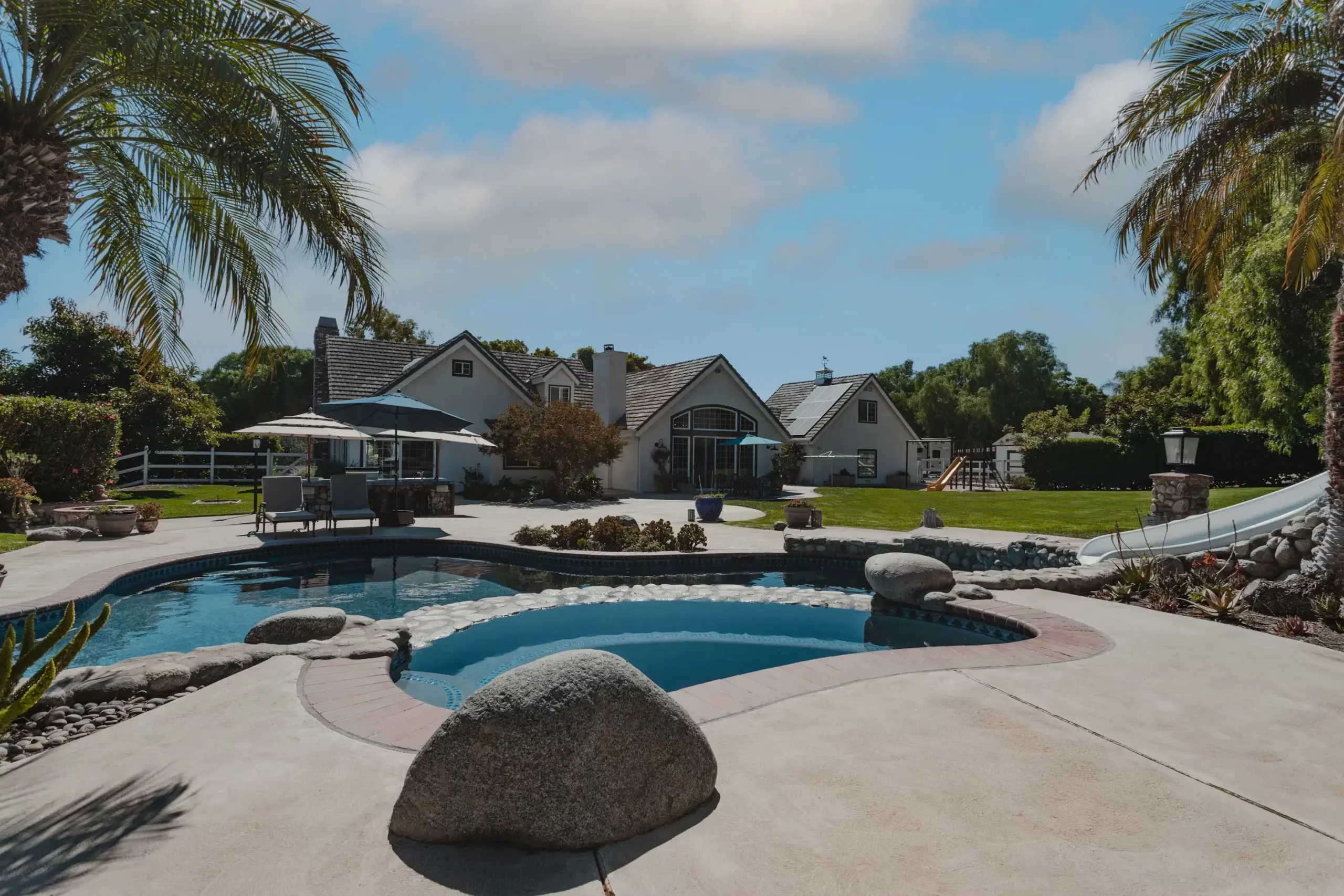
- Full Property Context: Drones reveal the entire property footprint – roof, yard, pool, and surroundings – helping buyers visualize the property in context.
- Standout Listings: Unique aerial angles and cinematic footage make listings memorable, giving agents a competitive edge in marketing.
Real Estate Drone Laws and Regulations
Operating a drone for real estate photography means following strict aviation rules. In the U.S., any drone over 0.55 lbs (250 g) must be registered, and commercial flights require a Remote Pilot Certificate (FAA Part 107). Key rules include flying at or below 400 feet, maintaining Visual Line of Sight, and avoiding restricted airspace (such as airports). Always yield to manned aircraft and keep drones clear of people and property.
In Europe and other regions, regulations differ. For example, EU rules now limit sub-250g drones to 120 m above takeoff. Many countries require drones to broadcast Remote ID or be operated within approved zones. Always check local laws before each flight — some parks, cities, or events ban drones entirely.
Licensing and Insurance
For commercial real estate work, obtain your FAA Part 107 pilot certificate and renew it every 24 months. In practice, this means passing an aeronautical knowledge exam and passing an online test every two years. Proper insurance is highly recommended; many clients or venues require liability coverage for aerial shoots. Meeting legal and safety requirements ensures professional, worry-free operation.
Choosing the Best Drone for Real Estate Photography
Selecting the right drone depends on your budget, image requirements, and local regulations. For most agents and photographers, a camera drone with at least 4K video and a 1″ (or larger) sensor is ideal. Here are some top picks for 2026:
- DJI Mavic 3 Pro: A professional favorite with a large 4/3″ Hasselblad sensor, 5.1K video, and up to 46-minute flight time. Its omnidirectional obstacle avoidance and O3+ transmission boost safety and range. The Mavic 3 Pro delivers stunning clarity on every shot.
- Autel EVO Lite+: Offers 6K/30fps video and 50 MP stills. It includes an adjustable aperture (f/2.8–11) for creative control, excellent low-light performance, and long battery life. A robust choice with professional features at a competitive price.
- DJI Air 3S: Featuring a 1″ sensor main camera and a 70mm tele lens, the Air 3S captures 4K/60 HDR footage and supports omnidirectional obstacle detection. It’s as portable as the Mini series but with pro-level imagery. Great for travel or quick shoots.
- DJI Mini 4 Pro: A compact 249g drone that shoots 4K/60 video and 48MP photos. Its lightweight design usually avoids registration, and it even rotates the camera for vertical shots. Ideal for quick scans and exterior panoramas when a larger drone isn’t needed.
- Potensic Atom X: A sub-250g mini-drone (no registration required in many regions) with 4K video and 3-axis stabilization. It’s ultra-portable with about 30-minute flight time, making it an excellent backup or for agents seeking a no-fuss aerial camera.
- Parrot Anafi USA: A rugged, weather-resistant drone with a 4K/60 camera and 32× zoom. It features thermal imaging and 180° tilt, letting you shoot challenging angles. This specialist drone shines for large estates and inspection tasks.
- Other Options: The DJI Air 3 (dual wide/tele cameras), Autel EVO Lite+ Pro, or even older models like the DJI Mavic 2 Pro or Phantom 4 Pro remain capable in skilled hands. Choose a stable platform with good battery life, obstacle avoidance, and spare-part availability.
In 2024, many professionals recommended the DJI Mavic 3 series and Air 2S for real estate; newer 2026 models like the Air 3S and Mini 4 Pro now raise the bar in imaging performance and convenience.
Preparing the Property and Shot
Plan your flight carefully. Check the forecast and pick a clear, calm day. Stage and clean the property before flying: remove cars, toys, and clutter from the yard, mow the lawn, and trim gardens. Early morning or late afternoon light produces soft shadows and appealing colors. Shooting during golden hour can be stunning, but watch for long shadows across the house. A tidy, sunlit scene will maximize the impact of your aerial images and save time in post-production.
Real Estate Drone Photography Tips
Capture stunning still images by following these practical tips:
- Optimize Camera Settings: Use a high resolution (shoot in 3:2 ratio for more pixels) and enable autofocus. Set ISO as low as possible and use neutral-density (ND) filters to maintain a fast shutter speed in bright conditions.
- Choose the Right Lighting: Early morning or late afternoon (golden hour) gives warm tones and soft shadows. Midday sun minimizes harsh shadows. In very bright scenes, ND filters help avoid overexposure.
- Keep the Drone Low: Instead of very high altitude, fly closer to the property (10–20 m) so building details are visible. Too much height only captures the roof and surrounding land, missing the façade.
- Highlight Key Features: Focus each shot on a standout aspect (pool, patio, garden, unique architecture). Frame these elements prominently (rule of thirds or centered) to draw the eye.
- Vary Your Angles: Don’t rely on a single viewpoint. Combine overhead and oblique angles from different sides of the building. This variety gives options and tells a more complete story of the property.
- Shoot in RAW: Always record images in RAW format. RAW files retain maximum detail and dynamic range, giving you flexibility to fix exposure and colors during editing.
- Practice Smooth Control: Fly steadily with gentle movements and avoid sudden jerks. Many drones have cinematic modes (like tripod or slow follow) that slow response for smoother capture.
Drone Videography Tips
Aerial video is a powerful marketing tool. Drones like the DJI Mavic 3 Pro and Autel EVO Lite+ (with 4K/6K capability) are often regarded as some of the best drones for real estate videography. Use these to capture smooth, cinematic footage by focusing on gentle flight movements, following the 1/2 shutter rule, and adding ND filters for video. Plan a variety of shots:
- Reveal Shot: Begin hidden (e.g. behind foliage) then fly toward the property, unveiling it dramatically.
- Orbit: Circle around the house or a key feature (pool, gazebo) to show all sides.
- Straight Approach: Fly directly at the property to emphasize symmetry or entrance.
- Top-Down / Bird’s-Eye: Descend from above for an overhead view (use sparingly for context or floor-plan perspective).
Keep movements slow and stable (avoid jerky pans). Capture footage at 50–60fps for smooth playback. In post-production, trim clips to the most engaging 1–2 minute sequence and add background music or narration to create a polished listing video.
Editing Aerial Images and Video
Great footage needs fine-tuning. Always shoot stills in RAW format to preserve detail, then adjust exposure, contrast, and color in software like Lightroom or Photoshop. Remove distractions (cars, litter) with clone/heal tools. For dramatic listing photos, consider specialized edits (day-to-dusk conversions or sky replacement) in post-production. When editing videos, color-grade for consistent lighting and trim the footage to highlight the main features. Aim for concise final clips (1–2 minutes) that move quickly to the next scene.
If you prefer a hands-off approach, professional Aerial Photo Editing and Video Editing services can deliver polished results quickly, saving you time on post-production.
Emerging Trends in Real Estate Drone Imaging
New technologies are shaping drone photography:
- AI-Powered Editing: Artificial intelligence can automate tasks like sky replacement, HDR blending, and virtual staging. Expect AI tools to speed up photo editing workflows and enhance aerial images with minimal effort.
- Day-to-Dusk Edits: Many photographers now simulate twilight lighting in post to create dramatic dusk images. This boosts engagement without the need for an actual twilight shoot.
- Immersive Tours: Integration with 3D virtual tours and VR is growing. Agents combine drone footage with 360° panoramas and virtual reality so buyers can ‘fly through’ a listing remotely.
- Smaller, Smarter Drones: The trend toward compact, sub-250g drones (e.g. DJI Mini 4 Pro) continues. These no-registration drones make entry-level aerial imaging easier. Advanced obstacle avoidance and autonomy are also improving safety for complex shots.
Drone Photography Across Property Types
Drone imaging applies to many real estate segments:
- Residential Homes: Capture the full yard, pool, and roof in one shot. Use drone video for neighborhood overviews and street approaches.
- Luxury Estates: Showcase expansive grounds, tennis courts, gardens, and water features. Drones portray scale and privacy in ways ground shots cannot.
- Commercial Properties: Provide aerial views of parking lots, building layouts, and access roads. Buyers of office parks or retail centers see the site in context.
- Land and Acreage: Highlight lot boundaries, topography, and proximity to landmarks. Aerial survey footage helps buyers appreciate the full area of farms, vineyards, or development parcels.
- Vacation Rentals & Hotels: Use sweeping video or 360° panoramas to emphasize location, such as beachfronts or mountain views, adding ambiance to listings.
- New Developments: For under-construction projects, provide periodic aerial progress photos or promotional fly-through videos to update stakeholders and future buyers.
Tailor your drone strategy to each niche: for suburban homes focus on curb appeal, while for rural land use high-altitude scans. Drones bring versatility to any property marketing plan.
Frequently Asked Questions
What is the best drone for real estate photography?
There is no single “best” drone for everyone — the choice depends on budget, skill, and needs. Professional agents often favor drones like the DJI Mavic 3 Pro or Autel EVO Lite+ for their excellent image quality (5K/6K video and large sensors). New compact drones (DJI Mini 4 Pro, Potensic Atom X) are great for ease of use and portability, especially on a budget or where registration is an issue. A good drone for real estate photography balances cost, camera power, and battery life. Consider what features matter most (gimbal stabilization, sensor size, flight time) before deciding.
Do I need a license to fly a drone for real estate?
Yes. In most countries, commercial drone use (using drone images to sell property) requires certification. In the U.S., you must hold the FAA Remote Pilot Certificate (Part 107), which involves passing an aeronautical knowledge test (with a recurrent exam every 24 months). Other regions have similar requirements (for example, EU A1/A3 certificates and Remote ID). You must also follow local rules: for example, in the U.S. you must fly under 400 ft, keep the drone in sight, and avoid restricted airspace without authorization.
What equipment and accessories are essential?
Bring spare batteries (each flight only lasts 20–30 minutes), extra propellers, and plenty of memory cards. Use neutral-density (ND) filters to control bright light. A landing pad protects your drone on rough or wet ground. Consider a tablet or monitor for framing shots on-site. Carry a power bank or charger for reloading batteries between flights. For safety: keep a fire extinguisher or sand nearby when charging, and have a first-aid kit (propellers are sharp!). A sturdy backpack or hard case designed for drones is essential to transport the drone and accessories safely.
How do drone photos help sell a property faster?
Aerial images give buyers a clear understanding of a property’s scale, layout, and setting. As noted above, listings with drone photos can sell up to 68% faster, and homes with high-quality visuals stand out online. Drone photos and videos highlight selling points (views, landscaping, proximity to parks or transit) that ground photos miss. This added visual appeal generates more leads and can tip the scales in favor of your listing. In short, great drone imagery makes a listing more engaging and can accelerate the sale.
How should I handle bad weather or wind?
Safety first: always check the weather before each flight. Drones can handle light wind, but strong gusts reduce stability and battery life. If wind exceeds your drone’s limit (often ~25–30 km/h), postpone the shoot. Most drones are not waterproof — avoid flying in rain or snow. Fog or low clouds also obscure detail, so it’s best to wait for clear conditions. After heavy wind or temperature changes, recalibrate your drone’s compass and sensors. It’s better to reschedule than risk a crash in bad weather.
How do I book a professional drone photoshoot?
If hiring a service, look for a certified drone photographer or agency (often listed as “aerial” or “drone” services). Provide the property address, size, and any special shots you want (aerial overview, close-ups, etc.). Schedule the shoot for a clear day, ideally when the client is available to meet on-site. Verify the pilot has proper credentials and insurance. A good drone service will handle permits (if needed), pre-flight planning, the shoot itself, and deliver ready-to-use photos and videos.
Elevate Your Real Estate Listings
Drone imagery is no longer a luxury — it’s a necessity to stand out. Whether you’re an agent, broker, or homeowner, professional drone content can make a significant impact. Get started today: contact our team to schedule a real estate drone photoshoot or inquire about our commercial drone services and image editing packages. Let us help you showcase your listings like never before and sell properties faster.